| Osm Go!
|
|
|
| Auteur :
|
DoFabien
|
| Licence :
|
MIT License (gratuit)
|
| Plateformes :
|
[[Android]] et Web
|
| Version :
|
1.5.0 see GitHub (2020-11-04)
|
| Langue :
|
english and multiple languages
|
| Site Internet :
|
https://github.com/DoFabien/OsmGo/wiki
|
| Installation :
|
|
| Code source :
|
DoFabien/OsmGo GitHub
|
| Langage de programmation :
|
Java
|
|
Simple POI editor app for Android
|
|
Features
| Feature
|
Value
|
| Map Display
|
| Display map
|
oui
|
| Map data
|
vector
|
| Source
|
online;cache
|
| Rotate map
|
oui
|
| 3D view
|
non
|
| Shows website
|
?
|
| Shows phone number
|
?
|
| Shows operation hours
|
?
|
| Routing
|
| Routing
|
non
|
| Create route manually
|
?
|
| Calculate route
|
?
|
| Create route via Waypoints
|
?
|
| Routing profiles
|
?
|
| Turn restrictions
|
?
|
| Calculate route without Internet (Offline routing)
|
?
|
| Routing providers
|
?
|
| Avoid traffic
|
?
|
| Traffic Provider
|
?
|
| Navigating
|
| Navigate
|
non
|
| Find location
|
?
|
| Find nearby POIs
|
?
|
| Navigate to point
|
?
|
| Navigation with voice / Voice guidance
|
?
|
| Keep on road
|
?
|
| Lane guidance
|
?
|
| Works without GPS
|
?
|
| Navigate along predefined route
|
?
|
| Tracking
|
| Make track
|
non
|
| Customizable log interval
|
?
|
| Track formats
|
?
|
| Geotagging
|
?
|
| Fast POI buttons
|
?
|
| Upload GPX to OSM
|
?
|
| Monitoring
|
| Monitoring
|
non
|
| Show current track
|
?
|
| Open existing track
|
?
|
| Altitude diagram
|
?
|
| Show POD value
|
?
|
| Satellite view
|
?
|
| Show live NMEA data
|
?
|
| Show speed
|
?
|
| Send current position
|
?
|
| Editing
|
| Add POIs
|
oui
|
| Edit / Delete POIs
|
oui
|
| Add way
|
non
|
| Edit geometries
|
non
|
| Edit arbitrary tags of existing OSM objects
|
oui
|
| Edit relations
|
non
|
| View notes
|
non
|
| Create notes
|
?
|
| Edit notes
|
non
|
| Work offline
|
online;offline
|
| Support imagery offset DB
|
non
|
| Upload to OSM
|
oui
|
| Rendering
?
|
| Accessibility
?
|
|
|
- Pour le projet de rendu 3D (une application Web) voir "OSM go"
Osm Go! est une application Android et une application web pour contribuer à OpenStreetMap. Il a une interface très simple pour collecter et ajouter uniquement des informations de POI à OpenStreetMap.
L'application peut également être utilisée dans n'importe quel navigateur utilisant osmgo.com.
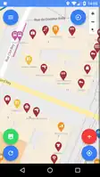
Interface
-
Interface principale et carte OpenStreetMap.
-
Interface principale et image aérienne satellite Mapbox.
-
Préréglages favoris.
-
Ensemble de modifications avant envoi au serveur.
-
Détails POI.
Voir aussi
Cet article est une ébauche. Vous pouvez aider OpenStreetMap en le complétant.
(merci de vous référer aussi aux autres traductions de cet article s’il y en a).
 Interface principale et image aérienne satellite Mapbox.
 Préréglages favoris.
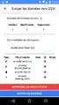 Ensemble de modifications avant envoi au serveur.
 Détails POI.