It has been proposed that this page be
deleted or replaced by a redirect. See the discussion page for further information.
The given reason is:
This page is a stub. This app is not related to OSM and all links are broken. --Nakaner (talk) 08:28, 10 October 2024 (UTC).
(Pages that link to this page.)
This page was last edited by Nakaner; 08:28, 10 October 2024 (UTC) (288 days ago).
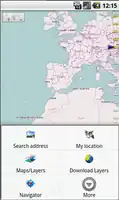
| gvSIG Mini
|
|
|
| Author:
|
Prodevelop S.L.
|
| License:
|
GNU GPL
|
| Status:
|
Broken
|
| Version:
|
1.2.2 (2011-03-30)
|
| Languages:
|
English and Spanish
|
| Website:
|
https://confluence.prodevelop.es/display/GVMN/
|
| Source code:
|
http://
|
| Programming language:
|
Java
|
|
supports WMS services, too; maps (online/offline-"custom")
|
|
Features
| Feature
|
Value
|
| Map Display
|
| Display map
|
yes
|
| Map data
|
raster;vector
|
| Source
|
online;cache
|
| Rotate map
|
yes
|
| 3D view
|
no
|
| Shows website
|
?
|
| Shows phone number
|
?
|
| Shows operation hours
|
?
|
| Routing
|
| Routing
|
yes
|
| Create route manually
|
?
|
| Calculate route
|
yes
|
| Create route via Waypoints
|
?
|
| Routing profiles
|
?
|
| Turn restrictions
|
?
|
| Calculate route without Internet (Offline routing)
|
no
|
| Routing providers
|
Yours
|
| Avoid traffic
|
?
|
| Traffic Provider
|
?
|
| Navigating
|
| Navigate
|
yes
|
| Find location
|
yes
|
| Find nearby POIs
|
yes
|
| Navigate to point
|
yes
|
| Navigation with voice / Voice guidance
|
?
|
| Keep on road
|
?
|
| Lane guidance
|
?
|
| Works without GPS
|
?
|
| Navigate along predefined route
|
no
|
| Tracking
|
| Make track
|
no
|
| Customizable log interval
|
?
|
| Track formats
|
?
|
| Geotagging
|
?
|
| Fast POI buttons
|
?
|
| Upload GPX to OSM
|
?
|
| Monitoring
|
| Monitoring
|
no
|
| Show current track
|
yes
|
| Open existing track
|
?
|
| Altitude diagram
|
?
|
| Show POD value
|
?
|
| Satellite view
|
?
|
| Show live NMEA data
|
no
|
| Show speed
|
?
|
| Send current position
|
?
|
| Editing
?
|
| Rendering
?
|
| Accessibility
?
|
|
|
gvSIG Mini is a free viewer of free access maps based on tiles with a WMS, WMS-C client, address and POI search, routes, hybrid location and many more things. It runs with both on/off-line modes.