It has been proposed that this page be
deleted or replaced by a redirect. See the discussion page for further information.
The given reason is:
The app had no outstanding features and cannot be installed any more. --Nakaner (talk) 09:29, 9 October 2024 (UTC).
(Pages that link to this page.)
This page was last edited by Nakaner; 09:29, 9 October 2024 (UTC) (288 days ago).
| Maverick
|
|
|
| Author:
|
Ulrich Grothaus
|
| License:
|
Proprietary (free, pd version available)
|
| Platform:
|
Android
|
| Status:
|
Broken
|
| Version:
|
2.8 (2017-02-15)
|
| Language:
|
English
|
| Website:
|
http://www.codesector.com/maverick.php
|
|
Geocaching support, POI Radar
|
|
Features
| Feature
|
Value
|
| Map Display
|
| Display map
|
yes
|
| Map data
|
raster
|
| Source
|
online;cache;offline
|
| Rotate map
|
yes
|
| 3D view
|
no
|
| Shows website
|
?
|
| Shows phone number
|
?
|
| Shows operation hours
|
?
|
| Routing
|
| Routing
|
no
|
| Create route manually
|
?
|
| Calculate route
|
no
|
| Create route via Waypoints
|
?
|
| Routing profiles
|
?
|
| Turn restrictions
|
?
|
| Calculate route without Internet (Offline routing)
|
?
|
| Routing providers
|
?
|
| Avoid traffic
|
?
|
| Traffic Provider
|
?
|
| Navigating
|
| Navigate
|
yes
|
| Find location
|
yes
|
| Find nearby POIs
|
yes
|
| Navigate to point
|
yes
|
| Navigation with voice / Voice guidance
|
?
|
| Keep on road
|
?
|
| Lane guidance
|
?
|
| Works without GPS
|
?
|
| Navigate along predefined route
|
no
|
| Tracking
|
| Make track
|
yes
|
| Customizable log interval
|
?
|
| Track formats
|
?
|
| Geotagging
|
note;photo;audio
|
| Fast POI buttons
|
yes
|
| Upload GPX to OSM
|
yes
|
| Monitoring
|
| Monitoring
|
yes
|
| Show current track
|
yes
|
| Open existing track
|
yes
|
| Altitude diagram
|
?
|
| Show POD value
|
?
|
| Satellite view
|
?
|
| Show live NMEA data
|
?
|
| Show speed
|
?
|
| Send current position
|
www
|
| Editing
?
|
| Rendering
?
|
| Accessibility
?
|
|
|
Maverick is a fully OSM based off-road navigation solution for Android devices.
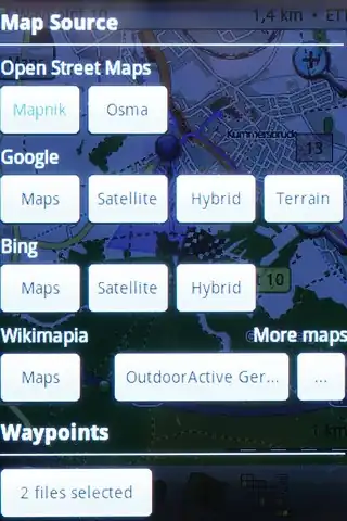
- Open Street Maps (Mapnik , Osmarender, Cyclemap, Public Transport)
- other maps: Google, Bing, outdooractive (Germany, Austria,South Tyrol) Nokia Maps, Cycloatlas (CZ, SK), Near Map Australia
- offline use: maps are automatically cached for offline use. However, Google requested Maverick that its maps are no longer cached.
- with the freeware Mobile Atlas Creator it is possible to convert maps from other formats (outdorractive, hubermedia,...) and use them offline
- complete POI handling with database, including 1 photo, and navigating to POI (no routing)
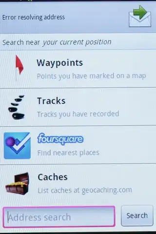
- searching online for POIs in a database in the web foursquare
- Geocaching feature: pocket queries on geocaching.com
- Share position online
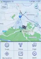
- Build-in radar shows the direction, distance and estimated time to a point of interest
- Record tracks, export/import tracks
- Upload tracks to GPSies.com
- Trip Computer: speed, altitude, pitch