Tag:aeroway=navigationaid
 |
| Description |
|---|
| A facility that supports visual navigation for aircraft |
| Group: aeroways |
| Used on these elements |
| Useful combination |
| See also |
| Status: de facto |
| Tools for this tag |
|
Air navigation aid stations support the different visual systems that help pilots guide their aircraft during flight.
For radio navigation systems use airmark=beacon.
How to map
Place a node at the location of the navigation aid, and tag with aeroway=.
Tags to use in combination
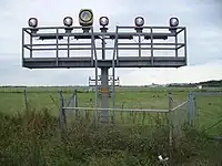
navigationaid=*– specifying the type of navigationnavigationaid=als–![[W]](./Tango_style_Wikipedia_Icon_no_shadow.svg.png) Approach lighting system
Approach lighting systemnavigationaid=papi– Precision approach path indicatornavigationaid=vasi– Visual Approach Slope Indicatornavigationaid=txe– Taxiway-Edge (blue)navigationaid=txc– Beaconing taxiway centreline (green)navigationaid=rwe– Runway edge (white)navigationaid=tdz– Touchdown zone (white)navigationaid=rgl– Runway guard light (yellow)navigationaid=reil– Runway end identifier lightsnavigationaid=beacon– rotating aerodrome beacon
Example
-
The approach lighting system of Bremen airport
-
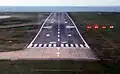 The PAPI can be seen to the right of the runway. The plane is below the glideslope.
See also
airmark=beacon– radio navigation aid systemman_made=beacon– often used as a complementary tag to this tagman_made=lighthouse– for tower used to display marine navigation lightman_made=compass_rose