Tag:aeroway=parking_position
 |
| Description |
|---|
| A location where an airplane can park. |
| Group: aeroways |
| Used on these elements |
| Useful combination |
| See also |
| Status: de facto |
| Tools for this tag |
|
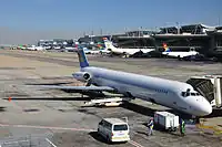
Location, usually on an aeroway=apron, where a plane is standing to board/disembark passengers or load/unload cargo. Each position has a unique ref within the airport.
If the parking position is at a aeroway=gate/skybridge, the ref=* is usually the same as the gate's ref. But it can sometimes be, typically on larger airports, different from the gate it is serving.
How to map
As a node
Put a node where the nose wheel stops. Tag the node.
As a way
Draw a way from the relevant taxiway and to the nose wheel position. The direction of the way indicates the direction a plane should park. This usually means that the last node of the way should be where the nose wheel is parked. Tag the way.
Tagging
Tag with aeroway=.
Additional information can be specified using these keys:
| Tag | Description |
|---|---|
ref=* |
The reference number / name of the parking_position. |
ele=* |
The elevation tag should be used for the altitude of the parking position. |
surface=* |
Use this tag if the physical makeup of the surface of the parking_position is different from the apron it is located on. Typical examples: paved, sand, grass, gravel, snow, unpaved. |
maxweight=* |
Use this tag for the maximum weight of aircraft to park at this position. Particular relevant to light aircraft tie-down positions, etc. |
Note
This is to document how this tag is used currently. It may not have been discussed or voted upon.