Tag:industrial=mine
 |
| Description |
|---|
| Mine - extraction of mineral resources from the ground |
| Group: industrial |
| Used on these elements |
| Requires |
| Status: in use |
| Tools for this tag |
|
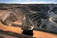
![]() Mine - extraction of mineral resources from the ground. There's two main forms of minery, surface and underground, and there's common traits and obvious differences.
Mine - extraction of mineral resources from the ground. There's two main forms of minery, surface and underground, and there's common traits and obvious differences.
Within the industrial area there would be spaces reserved to ore grinding, processing, washing, water drains, waste dump, as well as administration, workers barracks, leisure areas etc.
Note: for mines that are no longer in production, use historic=mine instead.
How to map
Draw a way encircling the area of the mine, tagging it as landuse=industrial and industrial=. Within this area there will be facilities associated to the mine, like:
- Space where parts of the industrial process is carried out, map correspondingly.
- The tailings basins, to be tagged as
landuse=basinandhazard=contamination, - Surface water management, composed of areas
natural=water/water=pondandwaterway=drain, which will likely be contaminated, too. It is of extra value if you can follow and map the destination of this potentially contaminated water. - Commercial and administration areas and buildings,
- Workers' barracks, as well as any associated amenities and leisure features.
Surface mining
Mark all quarries within the area as landuse=quarry.