Tag:man_made=quay
 |
| Description |
|---|
| A man-made structure alongside navigable water used for loading and unloading vessels. |
| Group: man made |
| Used on these elements |
| Useful combination |
| Status: in use |
| Tools for this tag |
|
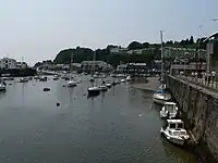
A ![]() quay is a man made structure along the shoreline or along the bank of a river or canal designed to allow vessels of some size to moor alongside it. In an industrial harbour a quay may have cranes and other facilities to unload cargo. For passenger vessels it may have facilities for passengers to embark.
quay is a man made structure along the shoreline or along the bank of a river or canal designed to allow vessels of some size to moor alongside it. In an industrial harbour a quay may have cranes and other facilities to unload cargo. For passenger vessels it may have facilities for passengers to embark.
How to map
Either draw a way along the shoreline or bank, or map the quay as an area extending landwards from the water's edge. In both cases, first trace a way along the water's edge (defined by natural=water or natural=coastline) making sure the new way is connected to it. If you are mapping the quay as an area, extend this line landwards, draw a closed way, and add area=yes.
Tag the way with man_made=.
For named quays, consider adding name=*.
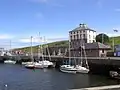
Picture
-
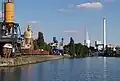 Industrial quay
 -
Wall of the quay
-
 Quay
Quay