Tag:natural=atoll
 |
| Description |
|---|
| A ring-shaped coral reef ithat encircles a lagoon partially or completely, and may include small islands. |
| Group: natural |
| Used on these elements |
| Requires |
|
| See also |
| Status: in use |
| Tools for this tag |
|
The tag natural= is used to map an atoll (sometimes called a coral atoll), a ring-shaped coral reef including a coral rim that encircles a lagoon partially or completely, and may include small islands or islets.
How to map
![]() As a node: if the full extent of the atoll, including the reef, cannot be yet be mapped, then place a node at the approximate center of the atoll.
As a node: if the full extent of the atoll, including the reef, cannot be yet be mapped, then place a node at the approximate center of the atoll.
![]() As an area: draw a closed way around the outer border of the reef, including all of the islands and the lagoon within the area. This is the most common way of mapping atolls.
As an area: draw a closed way around the outer border of the reef, including all of the islands and the lagoon within the area. This is the most common way of mapping atolls.
![]() Use a multipolygon relation if the atoll has more than one area; draw two or more closed ways and add each to the relation with
Use a multipolygon relation if the atoll has more than one area; draw two or more closed ways and add each to the relation with role=outer.
- Note:
place=islandmust be use the coastline when mapped as an area or relation, butnatural=should include the entire area of the coral reef and lagoon, in addition to any island or islets.
- Consider adding the islands to a multipolygon relation with
place=archipelagoif the group of islands has a name.
Tags used in combination
See also
place=island- for tagging each island within the atollplace=islet- for very small islandsplace=archipelago- to map the islands of the atoll or a chain of atolls.natural=coastline- to map the coast of any islands within an atollnatural=reef- to map the reef which surrounds the atollbiotic_reef:type=atoll
Examples
-
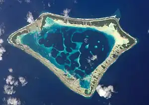
 Nukuoro Atoll (from space via NASA)
 -
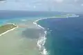 The coast of Bikini Atoll
 -
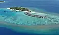 Raa Atoll, in the Maldives
 -
.jpg) Bora Bora aerial view
Bora Bora aerial view -
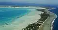 Tarawa atoll aerial view
 -
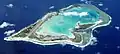 Wake Island atoll aerial view
 -
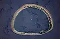
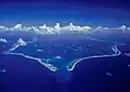 Penrhyn Atoll aerial view