Administrative levels
In Thailand there are 2 systems, the provincial and the local administration. References: wikipedia: Administrative divisions of Thailand and Thailand subforum.
The provincial administration is hierarchical and centrally controlled by Department of Provincial Administration and Ministry of Interior:
- Kingdom of Thailand > province > district > subdistrict > village
- Ratcha-anachak Thai > changwat > amphoe > tambon > muban
- ราชอาณาจักรไทย > จังหวัด > อำเภอ > ตำบล > หมู่บ้าน).
The local administration is administrated locally under the support of Department of Local Administration:
- provincial administrative organization (PAO), องค์การบริหารส่วนจังหวัด (อบจ.): same boundary as province.
- municipality (thetsaban, เทศบาล) has 3 classes:
- city municipality (thetsaban nakhon, เทศบาลนคร (ทน.))
- town municipality (thetsaban mueang, เทศบาลเมือง (ทม.))
- subdistrict municipality (thetsaban tambon, เทศบาลตำบล (ทต.)).
- A municipality can cover
- subdistrict administrative organization (SAO), องค์การบริหารส่วนตำบล (อบต.)
- can cover one or more adjoining subdistricts in the same district, also subdistricts partially if area shared with a municipality.
- community (chumchon, ชุมชน)
- is administrated by a municipality and can be the same size or smaller than a prior village.
References: wikipedia: Thesaban and wikipedia: List of cities in Thailand.
There are two special cases:
- is divided into districts (khet, เขต) which are further subdivided into subdistricts (khwaeng, แขวง) and communities (chumchon, ชุมชน).
- is a local administrative organization with no provincial administration. Local administrative organization are responsible for all provincial responsibilities.
- located in Amphoe Bang Lamung. Equivalent to the city municipality. The difference is minor, and it only affects a small portion of the administrative organization.
The table shows the values for Key:admin_level and for Key:place. Municipality extends in parallel to subdistrict and may be more or less than one subdistrict. 11 administrative levels are used. The table lists the terms for the administrative units in English, Romanized Thai and Thai.
| Country
|
Administration
|
Administrative levels admin_level=* and place=*
|
Non-administrative settlement
|
| 1
|
2
|
3
|
4
|
5
|
6
|
7
|
8
|
9
|
10
|
11
|
 Thailand Thailand
English / Romanized Thai / ไทย
|
Provincial Administration / Kan Pokkhrong Suan Phumiphak / การปกครองส่วนภูมิภาค
|
N/A
|
Kingdom of Thailand / Ratcha-anachak Thai / ราชอาณาจักรไทย
|
N/A
|
Province / Changwat / จังหวัด place=province
|
N/A
|
District / Amphoe / อำเภอ place=district
|
N/A
|
Subdistrict / Tambon / ตำบล
place=subdistrict
|
N/A
|
Village / Muban / หมู่บ้าน place=village
|
N/A
|
(see note)
place=hamlet or place=neighbourhood
|
| Local Administration / Kan Pokkhrong Suan Thongthin / การปกครองส่วนท้องถิ่น
|
(not to be tagged)
|
N/A
|
Subdistrict Administrative Organization (SAO) / Ongkan Borihan Suan Tambon (O Bo To) / องค์การบริหารส่วนตำบล (อบต.) place=county
|
N/A
|
| (see note)
|
Khwaeng / Khwaeng / แขวง place=suburb
|
(see note)
Village / Muban / หมู่บ้าน place=quarter or place=village
|
Community / Chumchon / ชุมชน place=neighbourhood
|
| Bangkok Metropolitan Administration / Krung Thep Maha Nakhon / กรุงเทพมหานคร
|
Bangkok / Krung Thep Maha Nakhon / กรุงเทพมหานคร place=city
|
District / Khet / เขต place=suburb
|
N/A
|
Subdistrict / Khwaeng / แขวง place=quarter
|
N/A
|
N/A
|
- The
place=* with admin_level=* should only be mapped as nodes. It can be linked to the equivalent boundary=administrative by adding it to the boundary's relation with role=label.
- Please note that many municipalities, especially the most recent ones, are still in rural areas and should not be tagged as
place=city or place=town, but rather as place=municipality. The criteria are:
- If more than 50% of the residential area* within the municipality boundary is connected as one settlement (no other area separating it), then tag it as
place=city or place=town
- (A residential area includes anything from residential, commercial, public park, and other public urban facility, but does not include a gated private residential estate or an industrial estate. The presence of a natural obstacle, such as a river or a major highway, does not imply that the residential area is separated.)
- If not, then tag it as
place=municipality
- (See the diagram below)
- If the original municipality area qualifies for
place=city or place=town, tag it as such, even if the current area does not.
- If there are more than one municipality qualifies for
place=city or place=town in one subdistrict, tag just the first founded one as such, and the others as place=municipality, unless each of them covered more than one subdistrict.
- If there are no more officially recognized villages in the municipality area, then tag it as
place=city or place=town anyway.
- Villages within the municipality area can be tagged as either
place=village or place=quarter. If the village is part of a larger settlement that is tagged as place=city or place=town, tag it as place=quarter. If the village is still distinct, tag it as place=village.
place=neighbourhood can be applied to any urban area with a name, whether it is an officially recognized community or not with the following exception: Private gated communities are tagged with landuse=residential for the boundary, name=* for the name of the community and barrier=gate with access=private where applicable.- All
boundary=administrative name tags should have a prefix (Thai) or suffix (English), but not all place=*. Only the node of provincial administration (place=province, place=district, and place=village) should be prefixed or suffixed. However, some place=neighbourhood should be tagged with prefix or suffix (ชุมชน / Community) if they used the name of a specific place, such as the temple, as the community's name, to differentiate them.
- The level-10
boundary=administrative's name tag should be หมู่ที่ xx / Mu xx, whereas place=village's name tag should be บ้าน xx / Ban xx.
- People should be able to recognize the name tag of
place=city and place=town. If no one uses the official name, such as the community or the business's branch, the more common name should be used instead, unless it is the same as the surrounding city/town.
- The level-10
boundary=administrative should not be removed as soon as the communities are established, because it may still be used for house addresses. Before removing it, ensure that the house address has already been changed to use a street instead.
- In some subdistrict, there may be more than one village with the same name because they are split for administrative purposes. In this case, they should be represented by a single
place=village node.
- Because of the small population in some remote areas, some distinct settlements may exist that are not recognized by the authorities (they are recognized as a part of nearby village). In this case,
place=hamlet is appropriate.
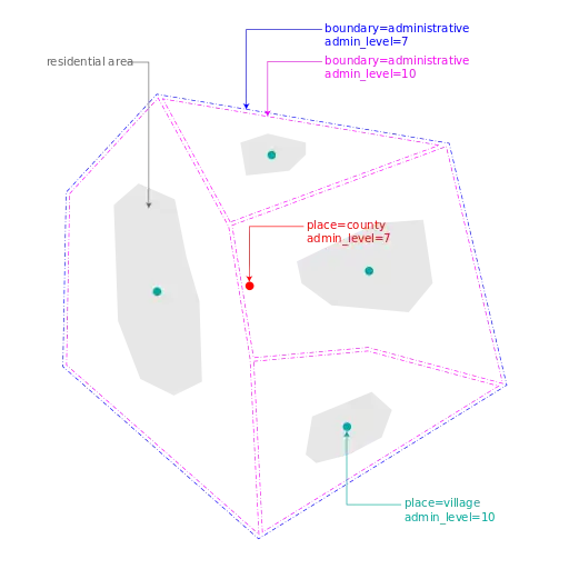
SAO area tagging examples
|
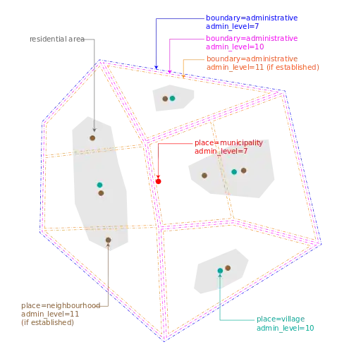
rural municipality area tagging examples (not more than 50% residential area connected together)
|
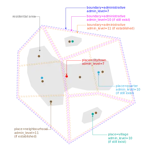
urban municipality area tagging examples (more than 50% residential area connected together)
|
|