Waterway Mapping Myanmar
Introduction
Waterway mapping in Myanmar is essential due to the country’s complex and diverse hydrological landscape, which includes major rivers, seasonal streams, irrigation canals, and delta networks. As a country heavily dependent on agriculture and shaped by monsoon patterns, accurately mapping waterways helps support disaster preparedness, irrigation planning, navigation, and environmental conservation. In Myanmar, major rivers like the Ayeyarwady, Chindwin, and Thanlwin play a critical role, while many local terms such as "chaung" and "inn" reflect unique water features found across regions. For OpenStreetMap (OSM) contributors, understanding these local characteristics and seasonal variations is crucial to producing reliable and locally relevant waterway data.
Objective
- To provide an easy-to-understand classification of waterway for digitization & tagging
Waterway Types & Tagging
Waterways include linear water features such as rivers, canals and streams, as well as water areas such as lakes, reservoirs and docks. Related features include barriers to navigation such as locks, weirs, dams, and rapids.
The main types are waterway=river, waterway=canal or waterway=stream, waterway=drain and waterway=ditch.
The following waterway values & tags are currently referencing by myOSM & Myanmar Mappers. There are still
| Free fllow | Pipe flow | |
|---|---|---|
| Artificial | waterway=canal | waterway=pressurised |
| waterway=ditch | ||
| waterway=drain | ||
| Natural | waterway=river | |
| waterway=stream | ||
| waterway=tidal_channel |
| Key | Value | Comment | Photo |
|---|---|---|---|
| Natural Watercourses | |||
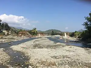
| waterway=river | river | A river is a wide, natural watercourse that flows from a source to an ocean, sea, lake or another river. For narrow naturally-formed waterways. A normal person could not swim across the river. see also for smaller, narrower stream waterway=stream.
|
 |
| waterway=stream | stream | A naturally-formed waterway that is too narrow to be classified as a river is often referred to as a stream. Typically, an active and able-bodied person should be able to jump across such a waterway. However, this definition does not fully apply to the context of Myanmar—particularly in the central dry zone.
In these regions, local residents often refer to certain waterways as "chaung" (ချောင်း), which is commonly translated into English as "stream." Despite the translation, many of these "chaung" can be quite wide in width, though usually shallow. During the rainy season, they may carry significant amounts of water, while in the dry season, they often dry up completely. It is important to note that the local classification of "chaung" is based more on cultural and seasonal characteristics rather than strict hydrological definitions. Therefore, some waterways labeled as "stream" in Myanmar may appear more similar to small rivers by international standards. |
 |
| waterway=tidal_channel | tidal_channel | A natural tidal waterway within the coastal marine environment with bi-directional flow of salty water which depends on the tides. | |
| Artificial waterways | |||
| waterway=canal | canal | A canal is an artificial open-flow waterway designed to carry water for specific purposes such as transportation, irrigation, or hydropower. In Myanmar, where agriculture is the main livelihood, most canals are built to distribute water from dams to farming areas. When mapping in OSM, contributors should use waterway=canal for these man-made channels. |  |
| waterway=pressurised | pressurised | A waterway where water is flowing in a fully enclosed conduit and subject to pressure; this includes gravity-driven penstocks and siphons and pump-driven pipelines. For eg. The Gyo Phyu Pipeline in Yangon City, Myanmar. | 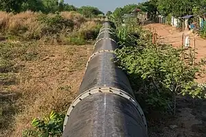 |
| waterway=drain | drain | An artificial free flow waterway used for carrying superfluous water like storm water or industrial discharge, usually lined with concrete, stones or similar. | |
| Barriers on Waterways | |||
| waterway=dam | dam | A wall built across a river or stream to impound the water. A dam normally does not have water flowing over the top of it. | 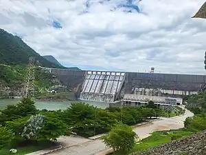 |
| Additional attributes for Waterways | |||
| intermittent | yes | Indicates that the waterway is sometimes dry and sometimes contains water. | |
| seasonal | yes, spring, summer, autumn, winter, wet_season, dry_season | Indicates that a waterway has a seasonal (yearly cyclic) flow, usually flowing continuously for at least some part of the year. | 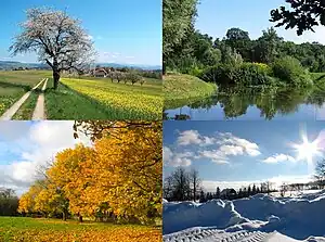 |
There are additional waterway classifications that have not yet been included. myOSM team will continue to update and expand the list of tags in the future to align with the Myanmar OSM waterways classification system. For reference, the original English versions of waterways classifications can be found on the OpenStreetMap Wiki at: Key:waterway
Waterway Mapping Tips
myOSM recommends using JOSM as the main mapping editor because it is flexible and has many useful tools.
Mapping waterways in the mountainous regions of Southeast Myanmar—such as Shan, Kayin, Kayah—is essential for improving the accuracy and completeness of OpenStreetMap (OSM) data in the country. These areas are characterized by steep terrain, seasonal streams, and dense vegetation, which require careful mapping using high-resolution imagery and, where possible, local knowledge. Contributors are encouraged to refer to [SouthEast Myanamar a small waterways projcet] for best practices and detailed guidance on how to map waterways effectively in such regions.
Please note that waterway mapping for the Central Dry Zone and Coastal Areas of Myanmar is still in progress. These regions require further exploration and verification due to their unique hydrological conditions. The myOSM Myanmar Team will continue updating these areas over time.
myOSM's JOSM Useful Mapping Tips
Use the following shortcut to easily map on JOSM. Which will help mapper to quick & more accurate building data.
- Use the keyboard shortcut “A” to make an easy node/digitize.
- Use the keyboard shortcut “S” to activate the select tool.
- Combing two or more features, select both by using "Shift" and use (“Shift + J”) to merge polyogn water
- Press “Ctrl” to avoid snapping to other features such as road, landuse etc.
- “Shift + Ctrl” to rotate the features.
- "Ctrl + Alt" to Shrink/Enlarge (Resize) features.
- "T" to split feature lines
- "C" to combine two or more features
- "Alt+A" to add tag popup