Wind farms
|
| Description |
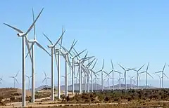
| Wind farms are a collection of wind turbines that share a common grid connection or operator. |
| Group |
|
power |
| Tags |
Wind farms are a collection of wind turbines that share a common grid connection or operator. The group (the entire facility) usually also has a name. To specify the properties of the entire facility, they can be grouped using a ![]() relation.
relation.
Notes:
- A wind farm is usually *not* a polygon, it is a relation. (See statements from UK, or Norway).
- The tagging scheme described further below has neither been established by formal proposal and vote, nor has it seen any significant use in map data since the page's inception (2018). See below.
How to map
site relation
- Note: "Site relations have poor support among data consumers"[1]
Create a ![]()
Relation tags
type=sitewithsite=wind_farmrecommendedpower=plantplant:source=windplant:output:electricity=number MW– if known (use a '.' dot as decimal separator, the indicated unit is usually 'MW' for megawatts or 'kW' for kilowatts)name=*– if known (note that the operator may name it differently than the local authority initially authorizing the plant site, and some local authority may grant a site concession to several operators)operator=*– recommended if available (you may want to addsource:operator=*); if the site has several operators, you may want to move this tag appropriately on each member generator, or use distinct relations, one per operator with their appropriate generators.start_date=2014-04-10– if known, set the date using the ISO format (yyyy-mm-dd, yyyy-mm, or yyyy)
Members
- Each generator as empty role; usually a single node (possibly an area polygon for a large tower). See
power=generator. - The wind farm substation should get the role substation.
- Maritime offshore wind farms may have a reserved area protected from navigation or fishing to protect their generators: that maritime area may be part of the relation. See
seamark:type=production_areaandseamark:production_area:category=wind_farm(for more details, Seamarks/Categories of Objects#Production areas (CATPRA)).
landuse
An alternative that is being discussed is tagging as landuse=*. E.g. landuse=windfarm.
This could be be used as a ![]() single area, as a multipolygon, or as a complement to site relation.
single area, as a multipolygon, or as a complement to site relation.
The use is not yet documented.
See also: Talk:Wind farms and Relation:site
Statistics
| Current frequency of the site relation |
Current frequency of seamark tagging |
There is also a small number of landuse tagging |
See also
- ↑ Relation:site (Revision from 2019 with initial statement)